
Segment 6
PROPOSED IMPROVEMENT
The North East Texas Regional Mobility Authority (NET RMA) is proposing to extend existing Toll 49 from SH 110 to US 271 as Segment 6 in the next phase of the East Texas Hourglass corridor. The environmental study is now underway with the project team conducting an Environmental Impact Statement (EIS). The purpose of Toll 49 Segment 6 is to relieve congestion and provide shorter travel times for regional and local traffic between SH 110 and US 271.
PROJECT UPDATES AND PUBLIC INVOLVEMENT
June 2, 2026 Update:
Please click the links below to access materials for the Toll 49 Segment 6 June 2026 public meetings.
- Video Presentation
- Presentation (PDF)
- Presentation Script (PDF)
- Exhibit Boards
- Fact Sheet
- Comment Form (print & mail)
- Online Comment Form
- Reasonable Alternatives Map on Aerial Image (see directions below for alternate means of viewing in Google Earth using KMZ file)
- Yellow Reasonable Alternative Schematic
- Teal Reasonable Alternative Schematic
The North East Texas Regional Mobility Authority (NET RMA) is continuing to develop Segment 6 of Toll 49 in accordance with the National Environmental Policy Act (NEPA) and other applicable federal and state regulations. The purpose of the proposed Segment 6 is to relieve congestion and provide shorter travel times for regional and local traffic.
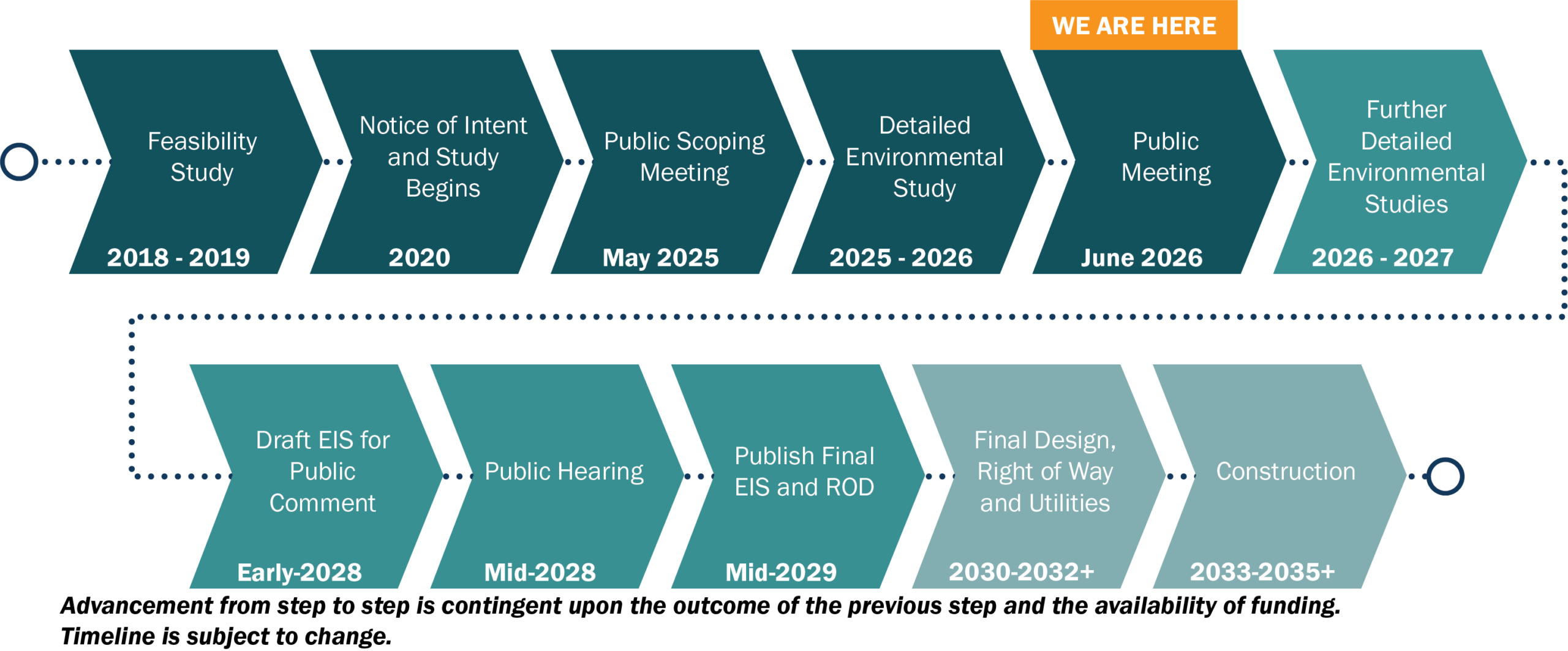
In May 2025, the NET RMA met with the public to gather input on three preliminary alternatives, along with a No-Build Alternative (in which the roadway would not be constructed), between SH 110 and US 271 northeast of Tyler. Since then, the project team has incorporated public input and evaluated the preliminary alternatives based on potential impacts to environmental and community resources.
As a result of that evaluation, two Reasonable Alternatives, along with a No-Build Alternative, are moving forward for further study in the Draft Environmental Impact Statement (DEIS). The public will continue to have opportunities to provide input on the proposed project through online comments, email, mail, voicemail, and in-person public meetings (with virtual attendance options) in Tyler and Longview.
The approved DEIS will be made available for public review and comment and will present the study findings and a Preferred Alternative. Public input on the DEIS will be sought during a public hearing anticipated to be held in 2028.
Final decisions regarding the preferred route option, which will also include a no-build option, are not expected until 2029 and will not be made without further public input. The purpose of Toll 49 Segment 6 is to relieve congestion and provide shorter travel times for regional and local traffic between SH 110 and US 271.
The purpose of public involvement is to share project information, present project updates, and gather public input. To learn more about upcoming and previous public engagement events, click the links below:
AGENCY COORDINATION
In accordance with the National Environmental Policy Act (1969), the project team is actively coordinating with local, state and federal agencies that have jurisdiction in the project area. This agency coordination is ongoing throughout the project development process.
The Agency Scoping Meeting for the Toll 49 Segment 6 Environmental Impact Statement (EIS) was held on August 27, 2025. The meeting provided an opportunity for federal, state, and local agencies with an interest in the project to meet and discuss the project, including: the draft purpose and need; the range of preliminary alternatives; the proposed methodology and level of detail for evaluating the alternatives; and the schedule for development of the EIS. Nine agencies attended the meeting, along with NET RMA, TxDOT, and project staff. Materials presented at the meeting are available for review at:
WHAT’S NEXT
The project team is currently in the “detailed environmental study” phase of the project and is developing design layouts that will include tentative ramp connections, right-of-way needs, as well as collecting data for route comparison purposes (length, construction cost, design traffic, number of residential and business displacements, acres of wetlands, potential air and noise impacts, etc. Further defined layouts and associated evaluation data will be presented at the June 2026 public meetings.
ADDITIONAL PROJECT INFORMATION
- Toll 49 Segment 6 Draft Purpose and Need (5/19/25)
- Toll 49 Segment 6 Public Involvement Plan (10/17/25)
- Toll 49 Segment 6 Draft Coordination Plan (10/17/25)
- Toll 49 Segment 6 Feasibility Study
- Toll 49 Segment 6 Feasibility Study Report Addendum
GOOGLE EARTH
The project team has plotted the current route options under study on Google Earth to give the public a closer look. You will need to install the free Google Earth software on your computer in order to use this tool. Click here to download Google Earth . Use the link below to access and download the KMZ file.
CLICK HERE: Google Earth (KMZ) File – Reasonable Alternatives
Contact us here: